TOURS
Best Tours Tour of Peru are at "Hannah Inka Tours & Adventures" tours are varied, and will adapt to the various individual and group needs of our Tursitas Scouts. In Peru we have endless landscapes, archeology, monuments, churches, museums, parks, festivals, snow, Amazon and more ... in all its land area, is north, center and south.
We mention some of the tours we offer our discerning tourists from Peru and the world.
We mention some of the tours we offer our discerning tourists from Peru and the world.
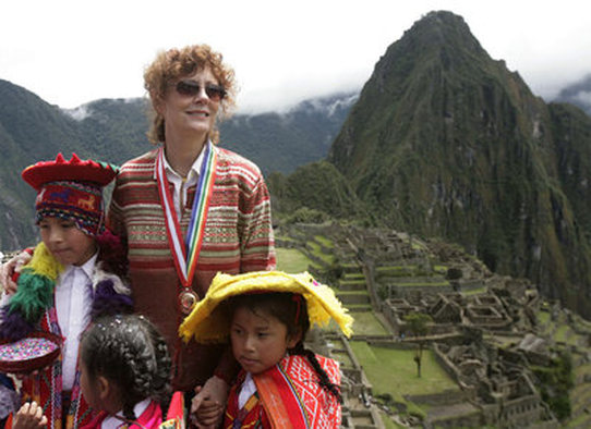
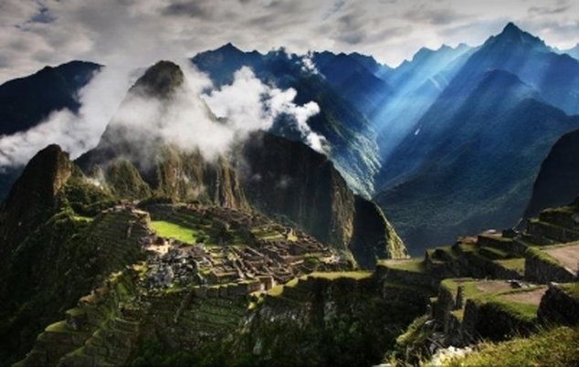
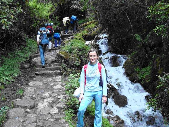
Inca Trail to Machu Picchu
The tour of this path Andean is an unforgettable experience. The road is paved with stone blocks and has stairs, tunnels and wooden bridges that cross rivers, temperate valleys, the warm and cold cloud forest highlands. All this set makes the visitor meditate about the intellectual and spiritual greatness of the Andean man whose highest achievement was the Inca civilization.
The Inca Trail to Machu Picchu is part of a system of more than 30,000 kilometers of roads that integrated the vast Tawantinsuyo, from southern Colombia to central Chile passing through Quito, Ecuador, Cajamarca, Huanuco, Jauja, Huamanga and Cusco in Peru, La Paz and Cochabamba in Bolivia to Salta and Tucuman in Argentina. These roads ran mostly along the coast and the mountains and in some cases reached the Amazon such as the Inca Trail to Machu Picchu.
The Inca Trail to Machu Picchu is part of a system of more than 30,000 kilometers of roads that integrated the vast Tawantinsuyo, from southern Colombia to central Chile passing through Quito, Ecuador, Cajamarca, Huanuco, Jauja, Huamanga and Cusco in Peru, La Paz and Cochabamba in Bolivia to Salta and Tucuman in Argentina. These roads ran mostly along the coast and the mountains and in some cases reached the Amazon such as the Inca Trail to Machu Picchu.
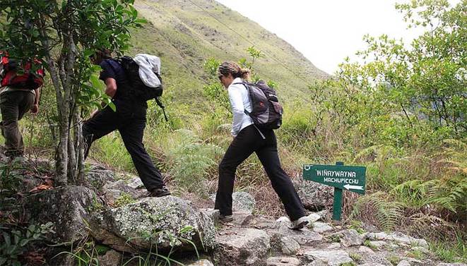
Description of the Inca Trail
The length of the route varies from three to five days depending on the chosen program. Some trails start in the town of Chilca and others in 76 or 88 kilometers, along the railway route to Machu Picchu. The roads belong to the ancient Inca Trail network and most of them are very well preserved. Since the beginning of the route, visitors can admire and explore more than thirty archaeological sites are within the sanctuary area. In general, these sites include homes, streets, walls, patios, irrigation canals, paths and deposits of food used by the ancient inhabitants.
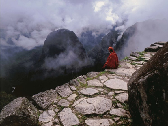
Among the most important sites include: Ccorhuayarachina, Patallacta, Pulpituyoc, Machu Quente, Willcaraccay, Trankapata, Huayllabamba Runkauracay, Sayacmarca, Rumi Wasi, Phuyupatamarca, Ccantupata, Wiñaywayna, Inti Pata, Huayractambo, Choquesuysuy and Intipunku (Sun Gate .) Just one of the most stunning scenery of Machu Picchu can be seen from this entry.
Among the most important sites include: Ccorhuayarachina, Patallacta, Pulpituyoc, Machu Quente, Willcaraccay, Trankapata, Huayllabamba Runkauracay, Sayacmarca, Rumi Wasi, Phuyupatamarca, Ccantupata, Wiñaywayna, Inti Pata, Huayractambo, Choquesuysuy and Intipunku (Sun Gate .) Just one of the most stunning scenery of Machu Picchu can be seen from this entry.
Royal Inca Trail
In 1995, local archaeologists discovered a new route to Machu Picchu Inca, it is accessible to visitors. It has the advantage that can be covered in 48 hours, starting at km 104 of the rail line. This road is known as the Royal Inca Trail, because of recent studies of ancient chronicles and archaeological research showing that this was the sacred route used by the Incas themselves. Following the new route, visitors can enjoy a beautiful panorama of the canyon of Vilcabamba (1,969 feet deep) and admire the archaeological sites of Chachabamba, Choquesuysuy Wiñay Huayna, Inti and Inti Pata Punko.
ACTIVITIES:
ACTIVITIES:
- archeology
- camp
- Ethno-cultural encounters
- Observation of plants
- observation landscape
- photography
- City Tour
- Hot springs (Aguas Calientes)
- Hiking
Caral: The oldest city in America
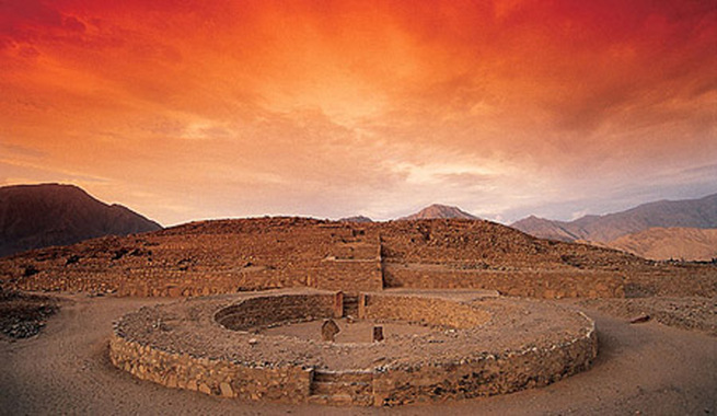
Caral is the oldest city of Peru (over 5000 years from today), and hosted the first Andean civilization that shaped the foundations of a social organization own unique, which along with Mesopotamia, Egypt, India, China and Mesoamerica are the foci originating from culture to the world.
Be builders of colossal pyramid-shaped buildings distinguishes the people of Caral in the other peoples of their time in the Andes. The pyramid in the Andes is a large-scale building used by the chiefs (rulers) as the center of their activities, whether religious, political or economic. It was the symbol and center of power. There he performed the ceremonies that would ensure the established order on dates designated by a ceremonial calendar that emulated the rhythm of nature.
The Pyramids of Caral is the oldest found to date in the Andes date back 5000 years (3000 BC). Building such structures required a high degree of technology and social organization to address the problems of construction and the high cost of materials and energy.
This ancient city of pyramids was erected on the left bank of the Supe river on a large terrace that is 350 meters above sea level. The site occupies an area of about 65 hectares. The Supe Valley is a narrow fertile valley in this place has a maximum width of 1.5 km and houses along its course a number of other contemporary sites Caral pyramids as: Age of Pando, Lurinhuasi, Miraya, Allpacoto , Rough, Chupacigarro, among others.
ic here to modify.
The City of the Pyramids
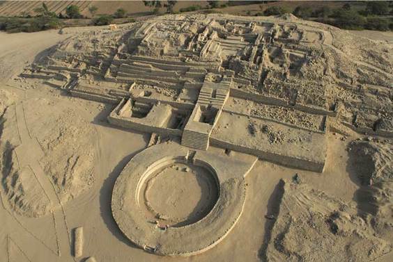
Caral include 7 large pyramids surrounded by several other small mounds adding 32 total. Its builders organized the city into 2 sectors: an upper (north) and a low (south). A former dry cause divides both parties. In the upper 6 major pyramids are located around an empty space. At the low end stands the Pyramid of the amphitheater and several smaller buildings aligned with it. The residential area is a group of houses where lived the people of Caral. These clusters of houses are made up of many interconnected rooms. Its walls are very narrow and are made of woven reeds covered with mud (technique called thatch). In some of these rooms have found evidence that were used as workshops for craft production (Shady 2004).
Caral
In each of the many pyramids of Caral were carried out different activities each fulfilling a different role in the social and religious order of its inhabitants. The Great Pyramid is located in the Upper Sector of Caral. It consists of a stepped pyramid volume (pyramid) and a circular plaza attached to the facade. A long run of 9 meters wide totals reaching 28 meters high, on top of the pyramid, joining the other two elements (square pyramid + loop), the main components of this building.
|
Highest Pyramid
Pyramid of the Quarry Lowest pyramid Pyramid Gallery Pyramid of the Huanca Pyramid of the Amphitheatre Pyramid of the Circular Altar |
153.52m
78.00m 45,80m 110.00m 55.00m 155.00m 42.60m |
109.42m
56.00m 37.00m 80.00m 55.00m 81.00m 28.00m |
28.00m
13.40m 7.50m 17,00m 12,00m 11,00m 4,00m |
The Lord of Sipan
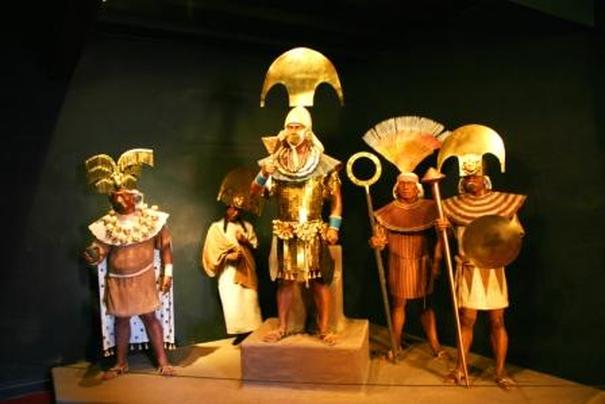
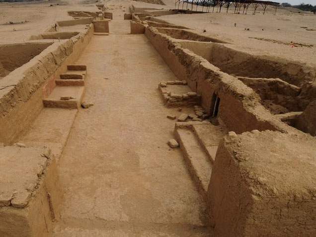
In 1987 was held scientific and historical recovery of the most important archaeological sites in terms of human remains and quritectónicos in Peru. These belonged to Mochica Lord who ruled the spectacular coastal valley of Lambayeque in northern Peru in the department of the same name. This manager hbría culture ruled the valley between the second and third centuries AD, and that after the discovery of his remains has been known as the "Lord of Sipan". Efforts to recover and restore valuable enclosures and main chambers were promoted by the archaeologist and researcher Walter Alva, who is a silent watcher of these ruins since its discovery and is one that has been responsible for leading the museum "Royal Tombs of Sipan "where the main parts and descubirmientos to keep it as a great cultural heritage. The remains of the Lord of Sipan have traveled the world as one of the human remains more care and more dazzling by the quality of the ornaments that accompanied him in his grave.
The Tomb of Lord of Sipan
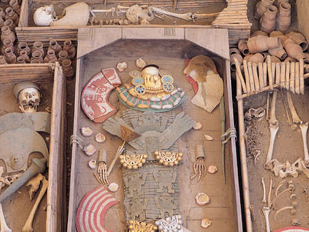
Inside the tomb of the Lord of Sipan was found several gold objects placed strategically and carefully to guard the sacred ritual. We found ornaments that were placed under the skull, protected by laminated pieces of gold that covered his chin. These were made to cover the neck at the top, chin and cheeks leaving a confidence to the nose. Also had some relief for placing the mouth and facial folds. For its use is difficult to believe they were made only for posthumous processes and not for use in everyday life. Besides these ornaments were two muffs with figures of deer. The figures were worked fine in turquoise and gold, and decorated with a border of 38 gold spheres delicate and perfectly welded. It was also found at the foot of cover chin, two gold nose rings slightly convex crescent complementing the majesty of the findings.
The site was covered with planks of wood over time accumulated a large amount of dust earth beneath them. Under these planks were carefully arranged 29 Moche pottery beside the body of the Lord of Sipan. These over time and the weight exerted by the wood and earth accumulated over hundreds of years, were fragmented by pressure. Among them was no evidence of organic remains and beverages believes were placed as offered up. The coffins were covered by three wooden tops connected by metal strips of 3 cm. thick, made from copper which were aligned moorings at four points, indicative of an excellent technique of woodworking and metalworking.
Under the boards of the main sarcophagus was found a human figure with arms outstretched in the form of angles. This couple had a finely crafted, and pectoral were superimposed without visible separation. Under these were found on the chest, gold thick discs 16 slightly convex and with two holes, one on each side of the disc, that with the use of some type of thread or filament may collar integrated impressive a total weight of 407 grams. Additionally two types of blades, one in each hand, known as "Tumis" a golden age and was in the right hand and the other was silver and was in the left hand. Also found four bones that accompanied the main body of the Lord of Sipan.
These coffins had original cane, but this material will disintegrate over time so that no remains of it today. Among the skeletons was that of a woman in her 20s wearing a breastplate of scallops in the chest, like the warriors who used this same piece of jewelry and is one of the best known in the museum located in Lambayeque: Royal Tombs of Sipan.
THE LOCATION OF THE RUINS OF THE Lord of Sipan "CRACKED HUACA"
It is located 28 kms. east of the city of Chiclayo. The Avenida Bolognesi take us to the Pomalca road, a distance of 7 kilometers, where you take a path to the right that will take you to the path Sipán.En the landscape is framed by extensive reedbeds. We observe small elevations and a small canyon formed by the river cause Reque. The archaeological features separate areas from each other, recorded monumental areas, playgrounds, cemeteries, domestic areas, fortifications, etc.. The monumental area of the complex is known as Sipan. Consists of several structures such as the Royal Mausoleum 80 X 130 ms. And 15 ms. high, the same as that recorded important evidence about the burial customs of the Moche. This rich Pre Inca sanctuary is considered the most important of the Inca culture, centuries I to VI investigations and discoveries continue at Sipan, The grave goods and the majesty of the Great Lord, King of the Moche the felt in the Museum site and the Bruning Museum in Lambayeque.
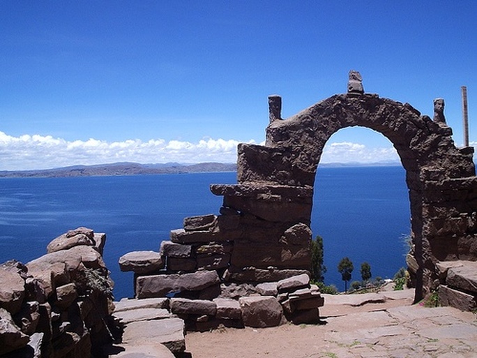
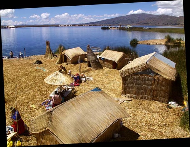
The Titicaca Lake
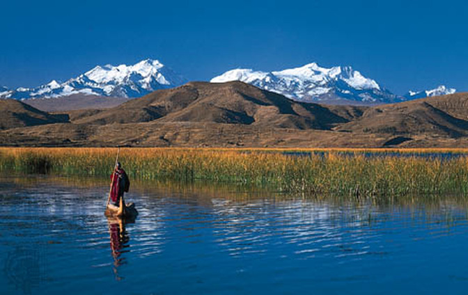
The lake the largest in the world above 2,000 m, and the highest navigable lake (3.808 m). It measures 194 km long and 65 km wide, occupying 8.710 km2 (5.260 in Peru, Bolivia 3.450 in) and has a maximum depth of 281 m., One can hardly imagine it takes at least a day to cross by boat. at this point, due to the purity of air, the lake is particularly clear (65 to 15 m.) and the light quality is exceptional, the mountains seem very close are actually 20 or 30 KM.EAST lake offers extraordinary fauna composed of ducks, fish such as search, the capache and trout, as well as alpacas and llamas among others. The flora is composed, among others, reeds, which are used not only as food but also as building material pair of houses, canoes, etc.Se are the Uros, living on floating islands of the lake, made of reeds, who are the descendants of one of the oldest towns in the Américas.El weather is dry and cool (20 ° C to 0 ° C), and rainfall is from December to April (annual rainfall 728 mm).
The Reserve of Lake Titicaca
The Titicaca Reserve is divided into two sectors: first, in the Bay of Puno, protects the reeds that sustain communities-Chulluni Uros. The adjacent area Huancané extensions totoral retains less visited but equally rich and interesting. In its vicinity there have been 60 varieties of birds, among which the endemic Titicaca grebe, 14 native fish species and 18 species of amphibians, including the giant Titicaca frog.
Climate: With large temperature variations between day and night. The ideal season to visit is between May and October, when the days are sunny, the rain is rare and the daytime temperature reaches 25 ° C. The nights, however, are always cold (though rarely below 0 ° C).
Access: There are scheduled flights to the city of Juliaca, located just one hour's drive from Puno. From the main port of the latter depart many boats that go into the lake and lead to the main islands.
Services: The infrastructure (accommodation and meals) is abundant in the lago.Se recommends a minimum of three days, spending at least one in any of the islands in the lake (as Taquile or Amantani).
The Nazca Lines
The Nazca Lines are undoubtedly one of the rewards from the tourist attractions of Peru. A 434 km south of Lima, Nasca and Pampas de San José, is a vast desert that stretches from the foothills of the Andes to the Pacific Ocean.
This desert is the site of the famous and spectacular drawings of animals (birds, reptiles and cats), lines and shapes, some visible from the earth and other from the air. There is an observation tower, but the best scenario is the aerial view. It is believed that the drawings were made by ancient Peruvians around 1000 AD, although there are even traces indicating that the area was occupied from 300 BC The first explorations in the area in 1926 were led by Peruvian archaeologist Theodore Xesspe Mejia, who believed that the lines were sacred paths made by the Nasca. Later, between 1939 and 1940, Dr. Paul Kosok of Long Island University, New York, suggested a possible link with astrology and noted that the lines could be part of an astrological calendar. In 1946 the German mathematician Maria Reiche, inspired by the thesis of Dr. Kosok, embarked on the difficult task of conducting surveys and measurements of these enigmatic drawings.
Dr. Reiche proclaimed that Nasca is one of the most important monuments of the ancient Peruvians and one of the most significant pre-Columbian civilizations in the Americas. One impressive aspect of these figures is the scale of their designs, some giants and other relatively small, all showing perfect proportions that would have been artistic, according to Dr. Reiche, thanks to the enlargement process using strings with predetermined measures and excellent knowledge of geometry. After measuring and identifying the orientations of the moon and sun relative to the positions of the drawings, Dr. Reiche said were used to observe the horizon, represent constellations, seasons recognize and indicate the appropriate time for planting and harvest.
Dr. Reiche on the meaning of each figure said: "As I mentioned a few times, even though there are diverse opinions on these drawings and their meanings, one thing is certain, is that the existence of these figures shows that the inhabitants of the Peruvian coast reached an unexpected level of culture. "
GEOMETRIC FIGURES AND HUMAN FIGURES
According to Maria Reiche totaling more than thirty geoglyphs found today in the Pampas of Nazca. These marine and terrestrial animals, shapes and designs are humanas.Los minor amount compared with the geometric designs consisting of hundreds and hundreds of lines, triangles and quadrangles that occupy large tracts of land. His technique was careful construction by the surveyors of the past took the lines to hills and ravines without deviating from its original direction. "The depth of the lines never exceeds 30 cm and some are mere scratches on the surface, but can still be recognized when the sun is low and the relief is accentuated, "explains Dr. Reiche.Entre larger geoglyphs are a bird of nearly 300 m, 180 m of a lizard, a pelican of 135 m, a condor of 135 m, a monkey of 135 m and a chandelier of 42 meters. These dimensions are cause for admiration. Reiche says that "a bird so big that one can be placed on the tip of one wing and can not even see the head or the other wing, you can only receive a few lines on the ground, they would have to fly the area to be appreciated as a whole. "By contrast, the smallest figure found so far is a spiral having a diameter of 3 meters. Almost half of the figures are made up of spirals and concentric patterns of various designs tamaños.Entre animals which are collected in Nasca include: a whale, a dog with long legs and tail, two llamas, various birds including herons, the crane, the pelican, the gull, the famous hummingbird and parrot. In the category of reptiles, an alligator, which was cut to build the American South, an iguana and a snake. On the other side are the towering figures of the monkey, the spider and the snail, among others.
Important figures of Nazca
Some key figures describe Reiche:
The Frigate Bird: The head of This giant bird is made of segments of circles radii range from Whose 10 to 20 cm The figure is stylized profile since two circles of equal diameter Could Represent Both eyes.
The Lizard: It Measures 188 m long. Its hind legs erased Were With The construction of the Bread, Which Divided Into the figure two.
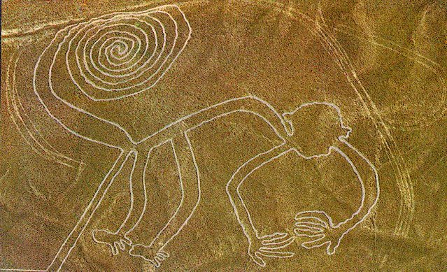
The Mono: Which Famous figure Measures Approximately 135 m and shows the animals with only nine fingers and a tail in a spiral. This is one of the leading figures and is Believed to Represent the Big Dipper.
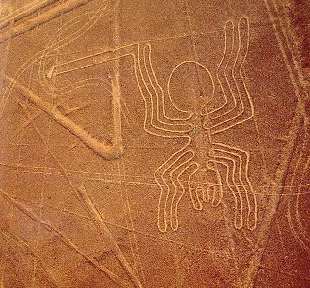
The Spider: Figure of 46 m in length That Lies Between a network of straight lines and is part of the edge of a huge trapezoid.
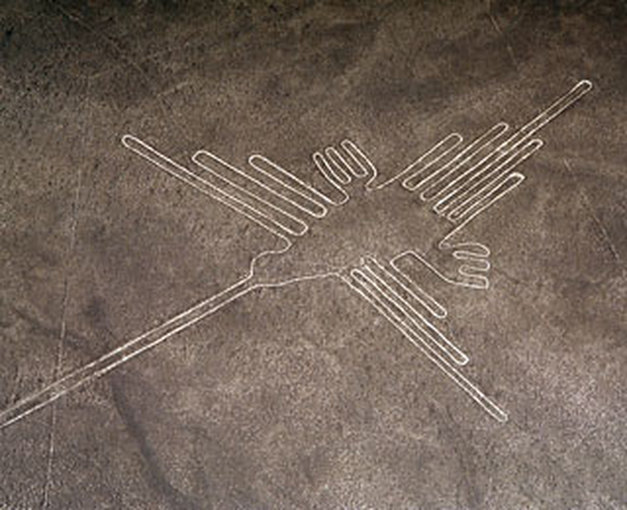
The Hummingbird: This is another of the geoglyphs ITS MOST famous for harmonious proportions. The Distance between the ends of STI wings is 66 meters.
The Giant Bird: This figure, drawn by a trapezoid, shows a large snake-necked bird Whose beak pointing to the rising sun. This huge bird has to total length of 300 m and a width of 54 meters is Considered by Scientists studying the pampas as the "Advertiser of the Inti Raymi" (Festival Inca sun worship), as if in the mornings from 20 to 23 June situáramos we follow him in the head and the sight of the direction of Their huge bills, We Could see the sunrise at Exactly the point made by This address.
Maria Reiche states That the geometric patterns are composed of six basic elements: quads. triangles, two types of zigzag lines, dashed lines oscillating centers. To this we add the figures in a spiral, Which Appear very often.
The Frigate Bird: The head of This giant bird is made of segments of circles radii range from Whose 10 to 20 cm The figure is stylized profile since two circles of equal diameter Could Represent Both eyes.
The Lizard: It Measures 188 m long. Its hind legs erased Were With The construction of the Bread, Which Divided Into the figure two.
The Mono: Which Famous figure Measures Approximately 135 m and shows the animals with only nine fingers and a tail in a spiral. This is one of the leading figures and is Believed to Represent the Big Dipper.
The Spider: Figure of 46 m in length That Lies Between a network of straight lines and is part of the edge of a huge trapezoid.
The Hummingbird: This is another of the geoglyphs ITS MOST famous for harmonious proportions. The Distance between the ends of STI wings is 66 meters.
The Giant Bird: This figure, drawn by a trapezoid, shows a large snake-necked bird Whose beak pointing to the rising sun. This huge bird has to total length of 300 m and a width of 54 meters is Considered by Scientists studying the pampas as the "Advertiser of the Inti Raymi" (Festival Inca sun worship), as if in the mornings from 20 to 23 June situáramos we follow him in the head and the sight of the direction of Their huge bills, We Could see the sunrise at Exactly the point made by This address.
Maria Reiche states That the geometric patterns are composed of six basic elements: quads. triangles, two types of zigzag lines, dashed lines oscillating centers. To this we add the figures in a spiral, Which Appear very often.
How to get to the Nazca Lines

By Air: Air Taxi (Lima-Ica-Nazca) and local flights over the lines of Nazca.Existen two airports in the department of Ica: 1) Aerodrome near the Hotel Las Dunas 5 kms. of Ica.2) Aerodrome "María Reiche Neuman", at Km 447 of the Panamerican Highway south (Nazca). By bus from Lima is eight hours away, By car, from Lima on the Panamerican Highway south to 303 km. The journey takes about 4 or 5 horas.Cuándo go: The Nazca Lines are located in the Peruvian coast, the summer season is from January to April is the most recommended (although there is little difference in the winter).
The Colca Canyon
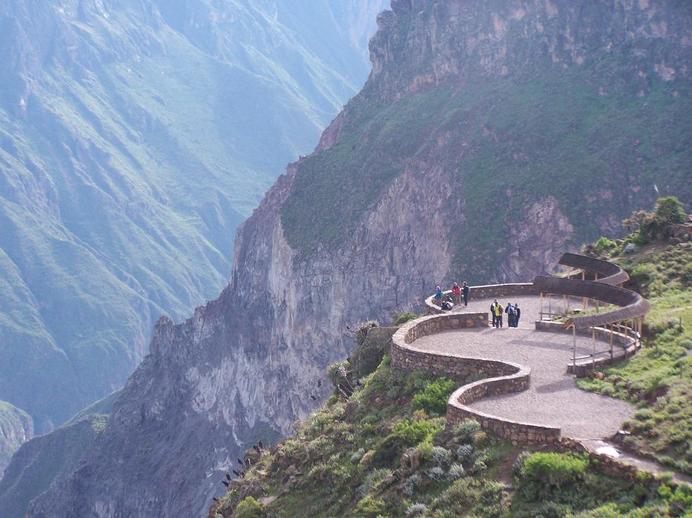
The Colca Canyon, considered one of the remarkable geographical locations of Peru, is in the cleft eroded most impressive of the Andes. It is twice as deep as the Grand Canyon in the United States.
The Colca Valley is formed by the Colca River, which originates at an altitude of 5,000 meters, the Condor Lookout, on the road from Arequipa to Puno. In its 450 km long Colca river changes its name twice, becoming the first Majes and then Camana name which flows into the Pacific Ocean.
Colca Canyon and the surrounding area offers many attractions, as well as geological interest that attracts. Leaving the city of Arequipa, the route crosses the Pampa Cañahuas Reserves and Salinas y Aguada Blanca. It is home to llamas, alpacas, guanacos and vicunas hundreds of which can be seen easily.
The surrounding landscape is dominated by huge and inactive volcanoes like Coropuna (6,425 meters) to the west and the Ampato (6,310 meters) to the east. The road passes through picturesque villages such as Chivay (3,650 m), famous for its hot sulfur baths (La Calera) and Yanque, among others.
The people of the Colca are especially attractive for its many churches built in the colonial era and the colorful clothing of its inhabitants, especially during the holidays.
One of the most impressive aspects of the trip is the opportunity to admire the large number of pre-Columbian cultivated terraces (about 60,000 hectares) and irrigation canals that are kept in perfect condition from those times. Some natural sites along the route, as the Cruz del Condor, offering spectacular panoramic views and have become points of observation to the flight of the great Andean condor.
Horseback
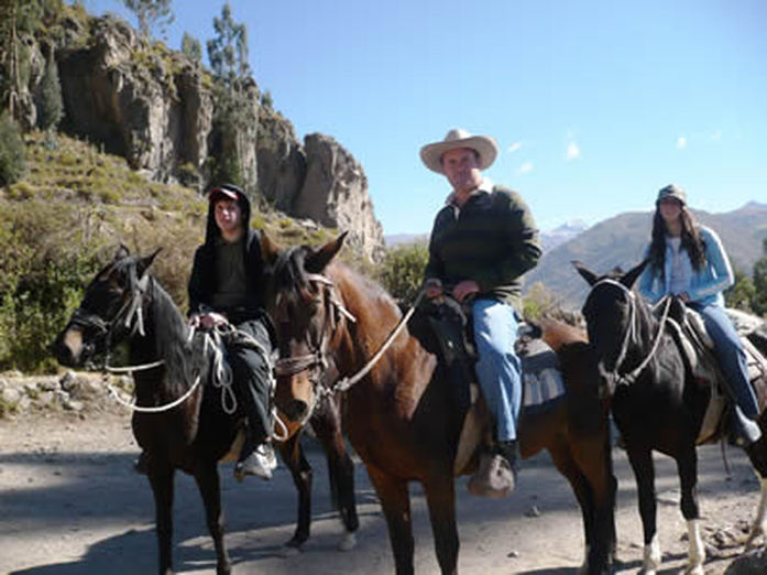
The rides are another way to meet and explore the area. Generally, this type of excursion lasts three to nine days. Access is by Chivay or Huambo, 160 miles north of Arequipa. The best time for this type of activity is between May and September.
Boating
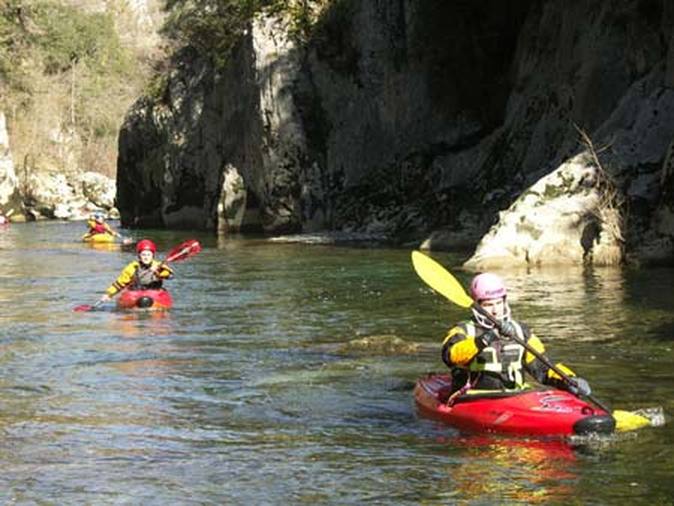
Those who enjoy boating know that the river Colca are turbulent and require skill and equipment. Participants must be experienced in canoeing and able to master fast with difficulty levels three to six points. Those who practice this sport in the Colca River described the trip as a spectacular experience in one of the most beautiful and interesting places in the world. The best season for rafting is between May and September.
Activities
- air Tours
- Archaeological sites (platforms)
- camps
- Wildlife viewing (exceptional place to admire the Andean condors)
- Excursions
- Horseback
- observation landscape
- Travel overland from Arequipa
- photography
- canoeing
- Tourist visits to the colonial monuments of Arequipa and Santa Catalina Convent
- baths
Chavin de Huantar
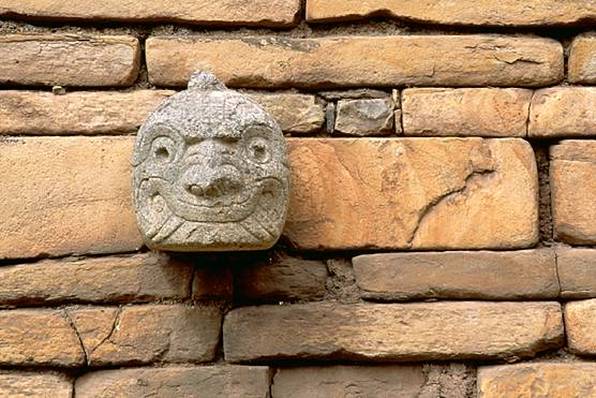
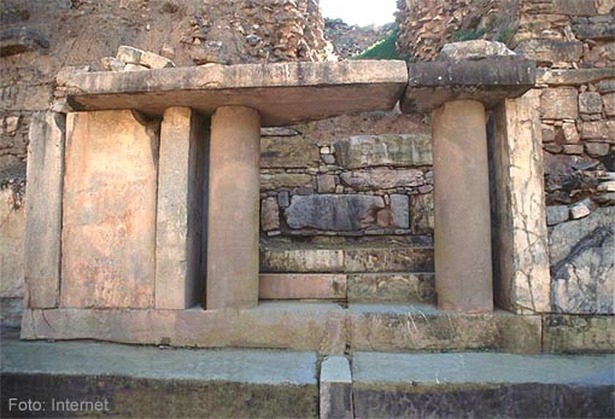
Chavin consists of several pyramidal buildings, plazas that sit on a hillside terraced doorways and stairways. The pyramidal structures house a network of passageways and internal chambers, which in some cases are superimposed. As raw material stone construction, although in some sectors the walls were plastered with clay that was burned to withstand the test of time.
Particular note is made up of stones portrayed with mythical figures and bas-relief high. Most of these enchapaban decorated walls and buildings and one of the sunken plazas. Meanwhile, in the form of carved stone heads built fierce expression were high on the walls, placed equidistant and horizontal row.
Constructs were developed Chavín from a nuclear structure made of mud and stones out of work, which had previously been scheduled for spaces which must be interior hallways or passages. Monolithic walls and lintels gained their independence these passages of the mass of mud and stones constitute construction. The artificial hill, perforated, so was built, he was inclined pyramid, which was interrupted by steps or "platforms". Finally, everything was coated on the outside with stone slabs or spun beautifully polished. The ravages of erosion are visible in the less resistant rocks, and this apparently makes some walls look today "imperfect" in sight. It is noteworthy that there was no lack of perfection in the construction of the bases of the exterior walls of "The Castle", as this sector looked originally covered or plated by large blocks of stone, square and that trend over time plummeted.
In the interior passages total and perpetual twilight reigns but for the light beams that pass through ducts or "vents" that communicate with the outside air and renew constantly. Perhaps for these products could hear the voices of the oracle of Chavín referred to earlier writers.
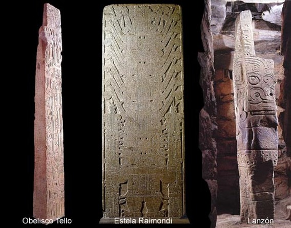
In one section of the internal passages stands the Lanzon, a monolith carved with mythical figures to be seen around. The huge stone is almost 5 meters high and overwhelms the viewer with their supernatural representations that "instill terror" as he expressed Antonio Raimondi, to which is added the location of the monolith in the perpetually dark galleries of Chavín.
Particular note is made up of stones portrayed with mythical figures and bas-relief high. Most of these enchapaban decorated walls and buildings and one of the sunken plazas. Meanwhile, in the form of carved stone heads built fierce expression were high on the walls, placed equidistant and horizontal row.
Constructs were developed Chavín from a nuclear structure made of mud and stones out of work, which had previously been scheduled for spaces which must be interior hallways or passages. Monolithic walls and lintels gained their independence these passages of the mass of mud and stones constitute construction. The artificial hill, perforated, so was built, he was inclined pyramid, which was interrupted by steps or "platforms". Finally, everything was coated on the outside with stone slabs or spun beautifully polished. The ravages of erosion are visible in the less resistant rocks, and this apparently makes some walls look today "imperfect" in sight. It is noteworthy that there was no lack of perfection in the construction of the bases of the exterior walls of "The Castle", as this sector looked originally covered or plated by large blocks of stone, square and that trend over time plummeted.
In the interior passages total and perpetual twilight reigns but for the light beams that pass through ducts or "vents" that communicate with the outside air and renew constantly. Perhaps for these products could hear the voices of the oracle of Chavín referred to earlier writers.
In one section of the internal passages stands the Lanzon, a monolith carved with mythical figures to be seen around. The huge stone is almost 5 meters high and overwhelms the viewer with their supernatural representations that "instill terror" as he expressed Antonio Raimondi, to which is added the location of the monolith in the perpetually dark galleries of Chavín.
ARCHITECTURE PLANNED
It is known that different conformational Chavin correspond to different historical periods that arose in the site. This statement belongs to Julio C. Tello. Years later, in 1962, John H. Rowe delved into the subject and supported in typological differences present in the monoliths proposed secuenciade architectural structures. He deduced that Chavin, as has reached us, was built starting from a modest base primordial temple: the "Old Temple." With the passage of time, this structure would have supported various extensions. At a later stage, we estimated was the third, would have established what it calls "New Temple" of major proportions and built next door, retaining part of the primitive structure of the monument. Rowe based his hypothesis protected in the presence of a sort of visible cracks in the walls and are considered vestiges of binding sites of the "additions".
However, the "cracks" that are supposed to have been produced by experienced increases from the "Old Temple" raise the suspicion that do not necessarily reflect the imprint of successive architectural extensions. Indeed, when these are comparadascon other Andean architectural examples which are also presented, it appears that there are simply printed marks deconstruct the technique on a modular basis, ie laterally adding sectors without incurring significant chronological separation. Moreover, the construction techniques between the "Old Temple" and "New Temple" of Chavín have no noticeable variations. And, that turns out to be even more significant, not the same architectural concepts and their symbolic values implied. Thus, it should raise the possibility that Chavin was conceived under one architectural plan, and that his execution was not a cultural or chronological delay consideration as to separate cultural stages.
However, the "cracks" that are supposed to have been produced by experienced increases from the "Old Temple" raise the suspicion that do not necessarily reflect the imprint of successive architectural extensions. Indeed, when these are comparadascon other Andean architectural examples which are also presented, it appears that there are simply printed marks deconstruct the technique on a modular basis, ie laterally adding sectors without incurring significant chronological separation. Moreover, the construction techniques between the "Old Temple" and "New Temple" of Chavín have no noticeable variations. And, that turns out to be even more significant, not the same architectural concepts and their symbolic values implied. Thus, it should raise the possibility that Chavin was conceived under one architectural plan, and that his execution was not a cultural or chronological delay consideration as to separate cultural stages.
Figure architecture
Exposed on the premise the hypothesis Rests That Seeks to Identify the outlines of a symbolic figure in the architectural complex of Chavin, Which naturally HAD broad strokes in only copied Some conspicuous figures of Chavin iconography, HAVING Simplifying forms to Adapt to the architecture.
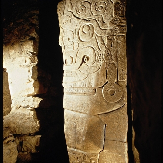
In the author in 1983 Proposing this hypothesis, The Possibility That the architecture would evoke an image Chavin zoomorphic and Trying to correlate the Various Sectors With The anatomical parts of Chavin HAD supernatural Being inspired, I ended up Arguing That the Chavin wall decoration, With STI Imprisoned for two two rows of major proportions, one below and one Above, due to the Could Be stylized mouths will include ad infinitum, by the retreat who accuse the lips in aggressive, leaving the sight of two rows of teeth.
As we know, the reason is the tiger Chavin iconography mouth, Excessive Strongly Represented in Both monoliths and ceramic objects made as in Various materials: sometimes Treated isolated and / or in succession and other symbolic figures Incorporating as a character.
Chavin's case representa a figure, as we suppose, This Possibility deserves attention and study Further, keep in mind there are other examples That in the architecture of ancient Peru constructions with zoomorphic indisputable Iconographic content, as Paramonga and Cerro Blanco in Nepeña. Also the architectural plan of The Haldas, pre-Chavín monument Seems to repeat the Same figure, basically Apparently a bird. The city of Cuzco Itself Would Have figured the outlines of a cat, Perhaps With A bird's head According To an old pattern and Widespread Andean iconography.
Chavin Monoliths
The Chavin style eloquently manifested in the architecture associated monolith of Chavin (of Huántar). These enchapaban, mostly, the walls of buildings.
The most spectacular monoliths are Chavin Stela Raimondi, the Tello Obelisk, the Lanzon and Columns. In the above examples of Chavin stone sculpture should join the Wake of Yauya, though not located at the site of Chavin. The figures represented in these monoliths observed degree of stylization and are accented by logeneral difficult to identify. This is aided to be dotted with a number of concepts included recharging representation, darkening it. Also, at first glance, the figures are incomprehensible, because they represent human beings and zoomorphic attributes drawn from mythical stories unknown. This has led to swarm the most diverse opinions as to what is represented.
The most spectacular monoliths are Chavin Stela Raimondi, the Tello Obelisk, the Lanzon and Columns. In the above examples of Chavin stone sculpture should join the Wake of Yauya, though not located at the site of Chavin. The figures represented in these monoliths observed degree of stylization and are accented by logeneral difficult to identify. This is aided to be dotted with a number of concepts included recharging representation, darkening it. Also, at first glance, the figures are incomprehensible, because they represent human beings and zoomorphic attributes drawn from mythical stories unknown. This has led to swarm the most diverse opinions as to what is represented.
Kuelap
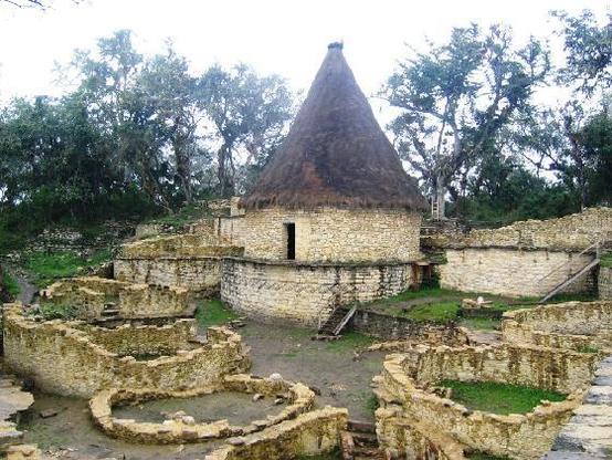
The Sachapuyos built imposing citadels on the tops of the mountains, to make the most arable land.
Their stone temples and fortresses harmonized with the incomparable scenic beauty of the region. A sample of the greatness of this people, of which little is known, is the fortified city of Kuelap, a dazzling jewel 3.000 m
The citadel of Kuelap in the department of Amazonas, is unique for its features and can not be compared with any of the archaeological remains in Peru. Its name derives from the distortion of the word "Cónlap" which is the name of a people who inhabited the area and taxed to the Spanish in 1591.
Kuelap consists of a series of terraces from 15 to 20 meters wide, on which stand formidable inclined walls. They emphasize their inputs built in funnel-shaped, with a width of 3 meters on the outside and 70 inches inside.
Some scholars say that Kuelap was discovered in 1841 by the 1st instance judge Juan Crisostomo Nieto, was inhabited between 500 and 1000 AD and that its construction would have used 25 `000.000 cubic meters of material, three times the volume of the Great Pyramid of Cheops in Egypt.
The inhabitants of Kuelap, abandoned their city before the Spanish arrived, for reasons that until now have not been discovered. The Italian scientist Antonio Raimondi, who first studied the area in 1860, at the place where the skeleton of a man six feet tall and skulls with blonde hair, creating an undeciphered mystery until today.
In Kuelap there is still much to discover and investigate. For now, this city, 584 meters long and 110 meters wide and walls 20 feet high, is covered by a veil of enigma and mystery, which covers all who visit
Tambopata- Candamo National Reserve
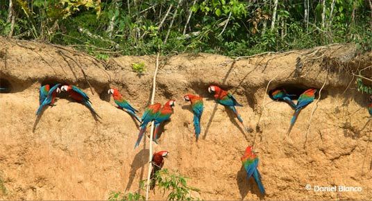
Officially created in 1990 as Tambopata - Candamo, located to the east and south of Puerto Maldonado. It consists of 1.5 million hectares (3.5 million acres) in the regions of Madre de Dios and Tambopata National Reserve Puno.La has been the subject of numerous television documentaries. We invite you to visit one of the largest macaw licks and mammals in the world. You can also visit the pristine Lake Sandoval. In this region, a person can walk a mile through the forest and never find two trees of the same species. Much of this diversity is due to the flora, the millions of species of insects and animals, heat, and weather húmedo.Al like the Manu National Park, the Tambopata National Reserve protects a large variety of landscapes and wildlife including lakes with herons, kingfishers, caimans and giant otters, spectacular waterfalls, amazing clay licks visited by hundreds of macaws, monkeys and tapirs, swamps filled with palm trees where birds nest different, rivers with sandy beaches for camping . All these wonders attract tourists, scientists and photographers silvestre.La life Tambopata region - Candamo holds several world records in flora and fauna of the region: 545 species of birds in just 5.500 ha. 1122 species of butterflies, 151 species of dragonflies and 29 species of beetles tigre.En 1996, part of the Tambopata area was declared Bahuaja Sonene. This new protected area that borders on Bolivia's Madidi National Park is the largest binational park mundo.Tambopata - Candamo can be visited throughout the year.
The Collpa
The "Collpa" is a Quechua name of the places where many animals congregate to eat mineral salts from the soil. Scientists believe that this behavior supplementing the diet of these animals. However, others believe that the ingestion of soil reduces the toxic effects of some wild fruits and spectacular clay lick l semillas.Las upper Tambopata River is famous Tambopata National Reserve. Hundreds of individuals of several species of parrots and macaws gather in this place. There are also smaller macaw clay licks in the river HeathAlgunas common species seen in these places are the blue and gold macaw, scarlet, red and green parrots also blue head and parakeets. Monkeys, tapirs, deer and capybaras are also seen frequently, that the clay is a low cliff Chuncho located along a tributary of Tambopata, 5 hours upriver from Puerto Maldonado (40 minutes Wasai Lodge). The Colorado is to lick one hour upstream from the lick Chuncho cliff is a higher altitude.
The Pampas del Heath
They are located near the border with Bolivia and contain large areas of grassland more than 100,000 ha. There is no forest, only shrubs. The fauna is very rich and two endemic species found here, a type of fox known as mane wolf and a deer type of wetlands. This is the only area showing these features unique to the Peruvian jungle, and therefore was not considered initially as a National Shrine and, more recently, was included as part of the Bahuaja Sonene.
